In Attendance:
Ron and Cindi Zuber from Seattle
Jerry Horn from Everett
Ed Pedersen from Vancouver
The morning dawned cool and foggy with a hint of the sunny day that was predicted. I shook out the cobwebs from the brain and headed over to North Vancouver to the rendezvous point at the White Spot restaurant.
All along Hwy #1 as I headed into Vancouver I was treated to the wonderful site of the North Shore mountains covered in new snow and lit up by the morning sun. This promised to be a gorgeous day indeed.
We met at the White Spot, ate breakfast while we got acquainted, (I think Jerry took some of my ham and eggs while I was looking the other way), and then set off for the day's exploration.
Once out of the restaurant parking lot we headed downhill to the foot of Lonsdale Street to drive past Lonsdale Quay, an indoor market. As the Lonsdale Street hill is quite steep and long, we were treated to our first vista of the day, that of downtown Vancouver still sleeping this early Sunday morning. At the foot of Lonsdale we turned west and followed Marine Drive as it wound it's way through North Vancouver and the affluent areas of Dundarave and West Vancouver.
As Marine Drive travels through West Vancouver the road is right alongside the water and we were treated to scenic views of the beaches of Spanish Banks in Kitsilano on the west side of Vancouver, as well as the huge Endownment Lands that contain the University of B.C. We passed million, two million, three million dollar houses located right on the water's edge, while some were precariously perched on the cliffs above us.
Marine Drive led us to Horsehoe Bay, site of the ferry terminal for the Province owned ferries that run between the mainland and Nanaimo on Vancouver Island. At Horseshoe Bay we took a sharp right and got on to the scenic Sea to Sky Highway heading for our first stop 10 miles north at Brittania Beach.
All along the highway we were treated to a never ending panascope of sunsplashed Gulf Islands and the cold waters of Howe Sound covered in white caps. We commented on how ironic that the wind was whipping up the water but there seemed to be no wind in the trees where we were. Interesting.
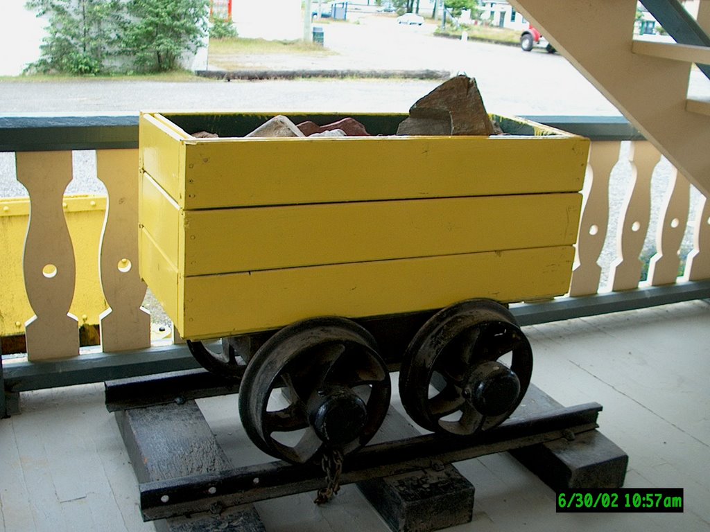
Well, we got the shock of our lives when we arrived at the old Brittania mine site and nearly froze our butts off! We reluctantly alighted from our vehicles to wander around the buildings and ore cars scattered around the museum area.
Brittania Mines began operations in 1905 and processed 7000 tons of ore daily until 1958, then operated intermittently until 1974, at which time it closed for good. These days the old mine offices are home to the mine museum, which we were unable to tour as it was closed for the season. We also did not get to go 1/2 mile underground on the rail tram that shimmies and shakes as it takes you inside the mountain to the end of an old horizontal mine shaft. Once there you are treated to a live demo of the various types of mining methods that were employed in the mine shaft. We did get a great view of the concentrator building that soared 200 feet up the side of a cliff above the mine offices.

We climbed back into the warmth of our vehicles and drove another ten minutes till we got to Shannon Falls. The falls are spectacular to see as the water drops over a small, smooth spillway 1200 feet above us, ricochets off the side of the cliff and lands noisly at your feet.

In and around Shannon Creek we saw examples of early logging techniques. We observed several old stumps 12 feet or so in circumference that had spring board notches on the side of the stump. Springboards were long boards about 5 feet in length on which the fallers would stand to chop down the tree. The springboards would give them the extra few feet of height off the forest floor to have more room for swinging the axes and the two man bow saws the fallers used in the late 1800's. Plus the extra height meant they didn't have to chop through the thicker trunk at the bottom of the tree, this made their job easier.
We also saw magnificent nursery logs...these are trees that have fallen on the forest floor and started to rot, providing fertile ground on which seedlings would grow. We came across one such example giving life to 4 younger trees!
In nature, from death there is life.
Back in the vehicles and five more minutes up the road brought us to the logging town of Squamish.
Squamish has been inhabited for thousands of years by the Squohomish tribes,
part of the Coast Salish Indians with their roots in Western Washington and Northern Oregon. Small wonder that many town and place names in BC sound similar to names in Washington: Skyhomish, Snohomish, Squamish, Stawamus, Snoqualmie; they are all names in the native tongue of the Salish Indians.
Did you know Squamish means "Mother of the Wind"?
This is an indication of the winds that rise from the north before noon on warm days, and blow steadily until dusk. This makes Squamish a top wind surfing destination and a host to the Proam sailboard races.
The first contact the local Indians had with white men was in 1792 when Captain George Vancouver came to Squamish to trade with the Indians just north of Squamish in what is now the residential area of Brackendale.
During the 1850s gold miners came in search of gold and an easier gold route to the Interior of the province. Settlers began arriving in 1889, with the majority of them being farmers settling in the Squamish Valley.
After a quick tour around downtown Squamish, which took all of 5 minutes, we drove a couple of miles north to Brackendale for our date with the Bald Eagles, and we were not disappointed. Along side the Squamish River we stopped at an area on the dike where the BC Forest Department has constructed covered areas specifically for eagle watching.
On the sign boards on the inside walls of the wooden structures were several displays of the life cycle of the Bald Eagle as well as other information such as their flight range. The Park Rangers on duty stated that the eagles fly from their summer grounds in Alaska to several Pacific Northwest areas such as Squamish, and another primary Vancouver area in the Harrison Valley 60 miles east of Vancouver in the Fraser Valley. In Washington the main area for eagles is along the Skagit River. Plus many other smaller rivers play host to the eagles, where ever there is a salmon run you will find the eagles.
Across the river from us, within a 1/4 mile stretch up and down the river, we counted 40 Bald Eagles sitting in the bare Cottonwood trees high above the river, more perched on huge driftwood piles on the riverbanks, and the odd one soaring on the air above us. The rangers perform an eagle count several times a day...they had just counted 60 a short time ago and at 9.30 that morning had counted 142 feeding on the dead and dying Chum salmon in the river at our feet.
We had an additional treat of sighting a Harbour Seal chasing the tired salmon in the shallows of the river. Between the view of the snow covered sun dappled mountains soaring above the valley, the Bald Eagles perched stately in the trees, and the cool sun of a winter's day, we were in heaven!!
Nature doesn't get much better than this.
As the day was still young, we opted to extend our agenda by making a run up to the Whistler ski resort. Shortly after leaving Brackendale, we entered the Cheakamus Valley and it's canyon area. The landscape changes here, gone were the wide open vistas of Howe Sound and the wide expanse of the Squamish River. In their place were the narrow confines of the Cheakamus Canyon and it's twisty, winding mountain road.
We gained elevation as we headed inland on a north-east course and broke free from the canyon as the road ran along the top of Cheekeye Ridge. It got colder and snow starting appearing on the side of the road as we approached Whistler.
It had been quite a few years since I had been up this way, and I was amazed at the growth that has taken place. Whole new villages existed where there were none before...in my younger days I climbed steep bluffs and ridges in the area for magnificent views of the valley. Now those same bluffs were covered in chalets and row upon row of condos.
Even the small village at Whistler has been swallowed up by a larger version of itself. It truly is a world class ski resort on par with the likes of Aspen in Colorado. There are wonderful hotels within Whistler Village with amenties to match. When you eventually pry yourself out of the hotel or one of the fine restaurants, or any of the numerous coffee shops, you have your pick of 200 downhill ski runs on Whistler and Blackcomb mountains.
We had a short look around at the Lower Village and at the open air shopping plaza that is the heart of the Village, then made a time check and realized we should reverse course, call it a day, and start heading back towards Vancouver.
Once again we headed through the narrow confines of the Cheakamus Valley, but this time when we exited the southern end, we were treated to a spectacular view of the snow covered Tantalus Mountain Range soaring up into the sunshine, and the Squamish River spreading wide as it headed through Brackendale, past the eagles, and onto it's date with the salt water of Howe Sound and the Pacific Ocean.

The rest of the drive consisted of more wonderful views of Howe Sound, with Gibsons Landing in the distance (where the TV series "The Beachcombers" was shot), and Vancouver Island off in the distance. The large ferries on the water heading for Horsehoe Bay reminded us that we were about to get caught up in the hectic pace of city traffic as the ferry from Vancouver Island was about to dock and would soon be off loading two hundred or so cars right into our path.
We chatted on the CB as we drove, all of us throughly pleased with what we had experienced during the day...there is only one word for it...AWESOME!
No comments:
Post a Comment